Flood assessment is only as good as the terrain data
A 10 cm error in ground elevation across a flat floodplain can be the difference between Flood Zone A and Flood Zone B. That’s the difference between getting planning permission or not, between affordable insurance or uninsurable.
The OPW Guidelines on Flood Risk Management require site-specific assessment for developments near flood zones. Drone LiDAR provides the terrain accuracy these assessments need, especially in the vegetated river corridors where it matters most.

Why LiDAR specifically
Vegetation is the problem
Floodplains and river corridors are among the most heavily vegetated places in Ireland – riparian woodland, rushes, reed beds, scrub. A standard photogrammetric survey maps the top of all that vegetation, not the ground. For flood modelling, it’s the ground surface that determines where water goes. LiDAR punches through vegetation to map the ground.
Accuracy that matters
Drone LiDAR hits plus or minus 2 to 3 cm vertical on bare earth. National airborne LiDAR datasets, where they exist, are typically plus or minus 15 to 25 cm. For a site-specific FRA where precise flood levels determine whether a development can proceed, that difference is significant.
Detail that national data misses
National LiDAR is captured at 2 to 4 points per square metre. Drone LiDAR gives you 50 to 300. At that resolution, you pick up drainage ditches, field drains, low embankments, and culvert inverts – features that control local flood pathways but don’t show up in coarser national data.
Flood risk assessment applications
Site-specific FRA
For planning applications needing Justification Test compliance under OPW Guidelines, the drone LiDAR DTM is the terrain foundation for hydraulic modelling. It feeds into:
- 1D/2D hydraulic models (MIKE, HEC-RAS, Tuflow) to simulate flood extents and depths
- Flood level comparison with proposed finished floor levels
- Flood extent mapping overlaid on the site layout
- Climate change scenario modelling (Mid-Range and High-End Future Scenarios per OPW guidance)
Working from CFRAM flood maps
The OPW’s CFRAM programme (Catchment Flood Risk Assessment and Management) produced Ireland’s national flood maps and the Flood Risk Management Plans covering 300 areas of significant flood risk, published through floodinfo.ie. Those outputs are the correct starting point for any assessment and we always check them first. What they are not built for is the individual site. CFRAM mapping models flood risk at catchment scale, so an extent drawn at that resolution can place a single property inside or outside a flood boundary on terrain detail that was never surveyed at site level. Where a planning decision or a finished floor level turns on that margin, a drone LiDAR DTM supplies the local ground the CFRAM mapping could not resolve, without contradicting it.
Strategic flood risk assessment
Local authorities updating SFRAs for Development Plans benefit from drone LiDAR for critical urban and peri-urban areas where national data isn’t detailed enough. Particularly relevant for towns where small watercourses and culverted sections create localised flood risk that coarse terrain data misses entirely.
Catchment analysis
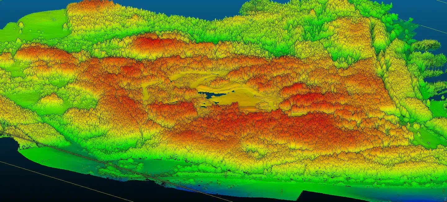
For greenfield sites, understanding surface water flow paths is essential for SuDS design. A LiDAR DTM lets you run hydrological analysis – flow direction, accumulation, watershed delineation – at a resolution that picks up natural drainage features and concentration points across the site.
Drainage design
Surface water
Drone LiDAR DTMs work well as the topographic base for surface water drainage design:
- Identifying natural drainage paths and low points
- Designing attenuation storage with accurate volume calculations
- Verifying gravity drainage feasibility (fall calculations)
- SuDS feature design – swales, detention basins, filter strips – where you need accurate existing levels
Agricultural drainage
For land drainage projects, LiDAR reveals the subtle terrain variations controlling surface water movement. Open drain condition, field drain outfalls, and wet spots all show up in the DTM and imagery.
Road and infrastructure drainage
For road corridor work, LiDAR captures verge levels, ditch profiles, culvert positions, and cross-fall. The data goes straight into Civil 3D for detailed design.
For OPW flood relief schemes, the data requirements are very specific. The bare-earth DTM needs to capture microtopography that controls where water flows at low velocities – berm heights, ditch inverts, subtle ridge lines that act as flow barriers. A 5cm vertical accuracy surface from LiDAR captures these features reliably. A photogrammetric surface over the same vegetated floodplain might miss them entirely because the camera can’t distinguish the ground from grass cover.
We’ve supplied LiDAR data for Section 50 consent applications and arterial drainage scheme reviews where the consulting engineers needed continuous cross-sections at 5m intervals along river corridors. Extracting that from a LiDAR dataset takes minutes per kilometre. Getting the same data from a traditional survey would mean a crew physically accessing every section point along the riverbank – dangerous, slow, and expensive in flood-prone terrain.
What we deliver
- Classified point cloud (.LAS): Ground, vegetation, buildings, and water separated for selective surface generation
- Bare-earth DTM: As TIN surface (.DWG/.XML), raster grid (.TIFF/.ASC), or both
- Digital Surface Model: Including vegetation and structures, for overland flow assessment
- Contour drawing (.DWG): Typically 0.25 m or 0.5 m intervals for detailed drainage design
- Cross-sections: At specified chainages along watercourses or drainage routes
- Hillshade visualisation: For picking out subtle features, drainage lines, and old channel positions
Everything in ITM with Malin Head heights – the standard for flood modelling in Ireland.
We work with hydraulic modellers regularly
We supply LiDAR terrain data to modelling consultancies working on FRAs for local authorities, OPW, and private developers. We know what MIKE, Tuflow, HEC-RAS, and JFLOW need in terms of format and resolution, and we make sure the deliverables are model-ready.
To discuss a flood risk or drainage project, get in touch. We’ll advise on survey timing, expected data quality, and formats. More on our LiDAR survey service.
Climate change scenarios and freeboard calculations
OPW guidance under the Planning System and Flood Risk Management Guidelines for Planning Authorities (2009, currently under review under the Planning and Development Act 2024) requires flood risk assessments to consider future climate scenarios. In practice, drainage engineers working on Irish projects need LiDAR ground data accurate enough to resolve the difference between two scenarios at the centimetre scale, because that difference can move a property in or out of a flood risk zone.
| Parameter | Mid-Range Future Scenario | High-End Future Scenario | LiDAR accuracy needed |
|---|---|---|---|
| Mean sea level rise | +500 mm by 2100 | +1000 mm by 2100 | Sub-100 mm vertical |
| Fluvial peak flow uplift | +20 per cent | +30 per cent | Sub-100 mm vertical |
| Pluvial rainfall depth uplift | +20 per cent | +30 per cent | Sub-100 mm vertical |
| Urban runoff response | Increased peaks and shorter concentration times | As Mid-Range plus higher return-period events | Sub-100 mm vertical and high point density for kerbs, ditches and gullies |
| Freeboard implication | 300 mm minimum above design flood level for sensitive developments | 500 mm minimum above design flood level for sensitive developments | Drone LiDAR at 20 to 30 mm vertical easily resolves these margins |
National LiDAR at ±150 to 250 millimetres vertical sits inside the same order of magnitude as the freeboard margin itself, which is why OPW-accepted best practice for site-level flood risk assessment increasingly calls for drone LiDAR where the freeboard decision is marginal. This is one of the most concrete reasons engineering consultancies commission a DSI drone LiDAR survey in addition to consulting the free national dataset.
Section 50 consent and the Arterial Drainage Act 1945
Engineers new to flood and drainage work in Ireland sometimes miss the role of Section 50 consent. Under the Arterial Drainage Act 1945, any works affecting a channel or structure within an OPW arterial drainage scheme require consent from the Commissioners of Public Works. That covers a long list of culverts, bridges, weirs and bank works across Ireland that fall inside a designated scheme.
The Section 50 application pack typically asks for: existing ground levels either side of the structure, invert levels, hydraulic capacity of the proposed works, and plans at a scale the OPW engineers can assess against their own design standards. Drone LiDAR delivers all four in a single flight, in the Irish Transverse Mercator grid and Malin Head vertical datum (OSGM15 geoid model) the OPW uses internally. This is a niche but high-value application for civil engineering consultancies working on small bridges, farm crossings, access road culverts, and drainage interventions near arterial watercourses.
Frequently asked questions
What LiDAR accuracy is required for flood risk assessment in Ireland?
OPW guidance under The Planning System and Flood Risk Management: Guidelines for Planning Authorities (2009, currently under review under the Planning and Development Act 2024) expects ground level data to be accurate enough to support defensible design freeboards. The national LiDAR coverage from OPW gives vertical accuracy in the ±15 to 25 centimetre range. For detailed site-level flood design, especially where a single contour can move a property in or out of a flood zone, drone LiDAR at ±20 to 30 millimetres vertical is the tool engineers rely on.
Can drone LiDAR be used alongside OPW CFRAM flood maps?
Yes, and that is normally how it is used. The CFRAM flood maps and Flood Risk Management Plans published by the OPW on floodinfo.ie set the catchment-scale picture and identify the areas of significant flood risk. A drone LiDAR survey does not replace them. It supplies the site-level bare-earth terrain that catchment mapping is too coarse to carry, so the hydraulic model of your site is built on measured ground rather than interpolated national data. Modellers typically take the catchment context and design flood levels from the CFRAM outputs, and the terrain for the site itself from the drone survey.
Why use drone LiDAR instead of the free OPW national LiDAR dataset?
The OPW dataset is excellent for strategic flood mapping and catchment studies, and we always start there. For site-level drainage design, attenuation sizing, section 50 consents under the Arterial Drainage Act 1945, and any case that may go to An Coimisiún Pleanála (formerly An Bord Pleanála), the national data is usually too coarse. Drone LiDAR captures the site at several centimetres vertical, picks up kerb lines, ditches and culverts the national data misses, and gives you a dataset that is current to the day of flight.
Does drone LiDAR see the ground through vegetation?
It sees enough of it to build a reliable bare-earth model on most Irish vegetation types. Our typical ground return rates are 20 to 35 per cent through mature deciduous canopy in leaf-off conditions, 10 to 20 per cent through dense conifer, and near 100 per cent over grassland, heath and reclaimed ground. For flood and drainage work we schedule leaf-off flights between November and March wherever possible. That is when drone LiDAR beats every other tool for catchment modelling.
Can drone LiDAR data be used in a planning submission or appeal?
Yes. Drone LiDAR deliverables from DSI include a survey report, residuals against independent check points, a classified point cloud, a bare-earth DTM, contour plots and cross sections in the formats Irish local authorities and An Coimisiún Pleanála accept for flood risk assessments and drainage submissions. Every project is flown under our EASA Specific Category authorisation and logged in Airdata, which gives a full audit trail if the data is challenged.
Free reference · ungated
Drone Survey Deliverables: Guide for Engineers
12-page reference covering every file format, coordinate systems, file size expectations, and Civil 3D + Revit import walkthroughs. Print it, share it, keep it on your desktop.
Related guides
For survey teams: For wider context on bringing LiDAR into your survey workflow, see our survey-supplementation guide.