3D Models and Digital Twins in Ireland
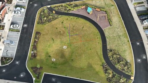
We create high-resolution photogrammetric 3D models and digital twins from drone imagery, providing construction teams, architects, heritage professionals, and infrastructure managers with a detailed virtual representation of their sites and assets. Our models are photorealistic, georeferenced, and delivered in formats compatible with BIM platforms, CAD software, and web-based viewers.
A 3D model captures the physical geometry of a site at a specific point in time. A digital twin goes further by linking that geometry to ongoing data, allowing the model to be updated with each new survey to reflect real-world changes. Both have practical applications across construction, heritage conservation, infrastructure management, and planning.

How We Create 3D Models
Our 3D modelling workflow combines multiple drone flight patterns to capture every surface of the target site or structure. Nadir (top-down) flights cover rooftops and terrain, oblique flights at 45-degree angles capture building facades and vertical surfaces, and point-of-interest orbits capture detail on individual structures from all sides. We plan each flight in UgCS with terrain-following enabled, and we adjust camera settings for optimal exposure at each angle.
The captured imagery, typically hundreds or thousands of overlapping photographs, is processed through photogrammetry software to generate a dense point cloud, a textured 3D mesh, and a georeferenced model. We use industry-leading processing platforms, including Pix4D, Agisoft Metashape, and Reality Capture, and select the best tool for each project based on the asset type, required detail, and intended deliverable format. For cloud-hosted viewing and sharing, we also use Propeller Aero and Sketchfab.
Ground control points (GCPs) and RTK/PPK positioning ensure the model is accurately placed in real-world coordinates, which is essential for measurement, comparison with design drawings, and integration with existing geospatial datasets.

Construction and BIM Integration
3D models and digital twins are increasingly central to construction project management through Building Information Modelling (BIM). Drone-captured 3D models can be imported into BIM platforms such as Autodesk Revit, ArchiCAD, and Navisworks, providing an accurate as-built record that can be compared against design models to identify discrepancies.
On active construction sites, periodic drone surveys create a time series of 3D models that track progress against the programme. These models support earthwork volume calculations, as-built verification, clash detection, and stakeholder reporting. Project managers, quantity surveyors, and design teams can access the model remotely, reducing the need for site visits and enabling faster decision-making.
For pre-construction, we generate base terrain models from survey data and insert planned structures to produce visualisations that show how a development will sit within the existing environment. This is particularly valuable for planning submissions and community engagement, where stakeholders need to understand the visual and spatial impact of a proposed development before construction begins.
Heritage and Archaeological Recording
Drone photogrammetry provides a non-contact method for recording heritage structures with millimetre-level detail. Our castle ruin model in Co. Meath demonstrates the level of resolution achievable: every stone course, wall profile, and structural feature is captured in the 3D mesh, providing a permanent digital record that can be measured, annotated, and shared.
Heritage 3D models serve multiple purposes. Conservation architects use them to assess structural condition and plan restoration works. Archaeologists use them to document excavation sites before and during work. Local authorities and heritage bodies such as the National Monuments Service and the Heritage Council use them for record-keeping and condition monitoring. For protected structures and national monuments, a detailed 3D record captured before any intervention provides an objective baseline for future comparison.
We also produce 3D models for heritage interpretation and public engagement. Models hosted on Sketchfab allow members of the public to explore heritage sites virtually, and fly-through videos generated from the model can be used in visitor centres, educational resources, and tourism marketing.

Infrastructure and Planning Visualisation
3D models provide valuable context for infrastructure projects of all scales. We have generated models of sports grounds, public buildings, industrial facilities, and mixed-use developments. Our 3D model of Pairc Tailteann GAA grounds in Navan demonstrates how a complete facility can be captured in a single survey session and presented as an interactive model for management, planning, and marketing.
For planning applications, 3D models allow applicants to show how a proposed structure will appear within its surroundings. This is increasingly expected by planning authorities and can be a decisive factor in gaining community acceptance for developments such as wind turbines, solar farms, and large-scale housing. Shadow analysis, viewshed assessment, and visual impact studies can all be derived from a georeferenced 3D model.
Deliverables and File Formats
We deliver 3D models in the format that suits your workflow. Standard deliverables include textured 3D mesh files (OBJ, FBX, glTF), dense point clouds (LAS, LAZ, PLY), and georeferenced orthomosaics. For BIM integration, we export in formats compatible with Autodesk, Bentley, and Trimble platforms. Cloud-hosted models on Sketchfab or Propeller Aero provide browser-based access for stakeholders who do not have specialist software.
If your project requires a specific coordinate system, such as Irish Transverse Mercator (ITM) or Malin Head vertical datum, we configure it during processing so the model is delivered ready for use without additional transformation.
Frequently Asked Questions
A 3D model is a static representation of a physical object or site at a single point in time. A digital twin is a 3D model that is linked to ongoing data and updated periodically to reflect real-world changes. In practice, a construction site surveyed monthly produces a series of 3D models that together form a digital twin, allowing teams to track progress and compare current conditions against design intent.
Yes. We export 3D point clouds and mesh models in formats compatible with BIM platforms including Autodesk Revit, ArchiCAD, Navisworks, and Bentley systems. The drone-generated model serves as an as-built record that can be overlaid on design models for comparison, clash detection, and progress tracking.
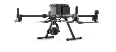
Model resolution depends on the flight altitude and camera specifications. Using our DJI Matrice 300 RTK with the Zenmuse P1 camera, we routinely achieve ground sample distances of 1 to 2 centimetres per pixel for close-range building surveys. Heritage structures captured with close-range oblique flights can achieve sub-centimetre detail on wall surfaces and architectural features.
Data capture on site typically takes half a day to a full day depending on the size and complexity of the asset. Processing time varies with the number of images and the level of detail required, but most projects are delivered within five to ten working days. For time-sensitive construction projects, we can prioritise faster turnaround.
Yes. We host models on cloud platforms such as Sketchfab and Propeller Aero, which allow anyone to view and interact with the 3D model in a standard web browser. This is particularly useful for sharing with stakeholders, committees, or members of the public who do not have CAD or BIM software.


