Multispectral Mapping
Multispectral mapping uses specialised sensors to map an area and detect non-visible light. It has many use cases, but we mainly use our sensors for precision agriculture and research and development projects.
The sensor detects the following bands in the electromagnetic spectrum: Blue (475 nm centre, 32 nm bandwidth), green (560 nm centre, 27 nm bandwidth), red (668 nm centre, 16 nm bandwidth), red edge (717 nm centre, 12 nm bandwidth), near-IR (842 nm centre, 57 nm bandwidth).
Some of the benefits of multispectral data
- Identify pests, diseases and weeds.
- Optimise pesticide usage and crop sprays through detection and monitoring
- Reduce costs by spraying the areas that require spraying
- Detecting nutrient deficiencies
- Help with land management and crop rotation. Develop policies based on real-time data.
- Count plants and determine population or spacing issues.
- Estimate crop yield.
- Measure irrigation. Control crop irrigation by identifying areas where water stress is suspected.
- Improve drainage based on the multispectral data.
- View crop damage from farm machinery and make necessary repairs or replace complex machinery.
- Assist with agricultural insurance claims


How is multispectral different to RGB mapping?
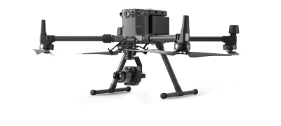
Our sensor is the industry-leading Micasense Altum, mounted on one of our DJI M300s. The drone is big enough to carry the weight of the sensor and provides long flight times. Multispectral mapping requires high overlap due to the smaller size of the sensors. For example, the sensor must be flown lower and overlap more than a high-resolution RGB. This smaller sensor increases the survey time and requires us to have sufficient batteries to complete it. As the sensor captures six images at a time, the data volume grows rapidly, often meaning that data management is done on-site.
A daylight sensor constantly measures the amount of light hitting it while the drone is flying. During a mission, the DLS measures the ambient light and sun angle for each of the camera’s five bands and records this information in the metadata of the TIFF images captured by the camera.
Specialised processing tools use this information recorded by the DLS to correct global lighting changes during a flight, such as clouds covering the sun.
We use the leading control station software, UGCS, to ensure consistent ground sampling distance due to its terrain-following features. The drone follows as the terrain rises and falls to provide the best-quality data.
We have completed hundreds of multispectral missions, capturing data and processing the outputs to provide the desired results. We price our jobs based on the location and size of the area, so contact us today to benefit from the best-quality data for precision agriculture.
We process the data using the industry-leading Agisoft Metashape, which allows us to process RGB, Multispectral, and Thermal imagery with one software package.
What is multispectral imaging used for?
Multispectral mapping is essential for precision agriculture. Before chemicals or fertilisers are sprayed or added to the land, you must know where they are required.
By mapping the land with multispectral sensors, you can quickly and easily see where intervention is needed.
Vegetation Indices
Many vegetation indices can be applied to multispectral mapping outputs, and one of the most common is NDVI or normalised difference vegetation index. Indices are algorithms applied to the raw output, and specific bands are used to calculate the results. The formula below outlines how NDVI is calculated by applying this formula to the specific bands of data.

Some operators and platforms offer “NDVI”, but this is not accurate multispectral imaging. They use standard RGB lenses and apply colours to the data. This is known in the industry as “fake NDVI”. This data is almost useless as the RGB sensor cannot capture the required bands.


