Drone LiDAR Surveying
Advanced drone technology delivering centimetre-level accuracy across multiple industries
- High-Precision 3D Mapping and Survey Data Collection
- 75% Savings compared to traditional surveys
- Professional LiDAR Mapping for Construction, Mining, and Forestry
- Rapid Large-Area Surveying and Digital Terrain Modelling
- Advanced Drone LiDAR Technology and Real-Time Processing
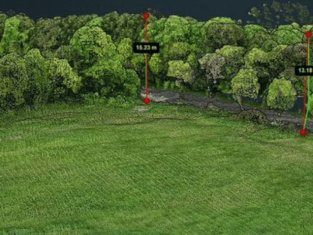
- Create Accurate Measurements and calculate the distance between data points


High-accuracy drone LiDAR and inspections for complex sites,
engineering-ready data in 2 working days.


What is LiDAR and How Does it Work?
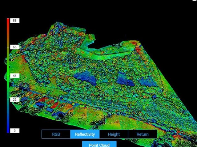
Drone LiDAR surveying involves using aerial platforms with Light Detection and Ranging (LiDAR) sensors to generate accurate 3D mapping solutions. It is essentially a lidar scanner in the sky. Rapid laser light pulses, up to 500,000 points per second, record how long each laser beam takes after hitting a surface. These laser pulses penetrate the vegetation canopy, where possible, even in cases of very dense vegetation, and thus can create an accurate surface of the ground.
Our systems integrate high-precision GPS/GNSS positioning and Inertial Measurement Units (IMUs) to accurately document sensor orientation and position during flight. This results in a georeferenced point cloud of survey-grade quality, with an accuracy of up to 5 cm. Unlike classical photogrammetry, LiDAR doesn’t require bright light and can collect points from beneath a forest canopy.
This data is processed via sophisticated algorithms that classify points based on ground, vegetation, buildings, and other characteristics. Planned deliverables include point clouds, Digital Terrain Models (DTMs), point grids, and vegetation density. The system is particularly appealing for forestry, corridor mapping, and complex infrastructure projects, where obtaining hundreds of return hits on a traditional survey is difficult.
However, this includes generating a 3D model based on the numerous measurements in the point cloud. After processing these points, surveyors can generate high-quality Digital Terrain Models (indicating bare earth) and Digital Surface Models (indicating all features, including vegetation, buildings, and other elements). The differences between these models can yield important insight into vegetation height, building dimensions, and small changes in terrain that may be indicative of archaeological features or geologic formations.
This technology is particularly useful in complex environments where traditional surveying techniques may be ineffective. In forestry, you can also calculate tree heights and the density of forest cover while mapping the ground below. In archaeology, it can uncover ancient settlements buried under vegetation. The data used in infrastructure and construction enables precise calculations, allowing plans to be created efficiently and ensuring quality delivery.
LiDAR Data Analysis
ASPRS classification standards are a universally used system for consistently classifying data.
A complex way to organise the millions of data points you gather. Just as a librarian re-arranges books into different categories, LiDAR data points are separated into standard classes: ground, low vegetation, medium vegetation, high vegetation, buildings, etc. This standardisation means surveyors worldwide can speak the same ‘language’ when working with LiDAR data.
This becomes even more powerful if we filter and analyse these classified points. For a first-of-its-kind technique with no precedent, traditional photography can only observe the part above ground, like mapping the floor of a dense forest from the air. It would be impossible. However, because LiDAR can detect gaps in trees and plants, we can request that it remove the layers digitally, exposing features that may not be visible to the human eye or regular surveying methods.
Industry-Leading LiDAR Technology
The differences between drone LiDAR and traditional photogrammetry are apparent in challenging environments.
Photogrammetry utilises digital imagery, which requires specific conditions for optimal results. LiDAR uses laser beams to generate a surface by measuring the return time of the pulse to create a terrain model.
A laser pulse (or set of pulses) records multiple returns as it interacts with various surfaces, layering spatial information on top of one another. One pulse, for example, can be reflected first off a treetop canopy, then branches at different heights, and finally the ground. All these returns are tracked with precise positioning data, resulting in a point cloud, a high-resolution digital twin of the surrounding real world.
Do you need to see bare earth underneath thick vegetation?
The classified point cloud enables this by filtering out non-ground features.
Do you want to isolate individual features, such as buildings or power lines?
Point Cloud classification enables you to filter precisely what you need to review with pinpoint accuracy. Removing unnecessary features makes visualisation much easier, as these layers can be toggled on and off depending on the requirements.
What makes LiDAR measuring different from other methods of surveying is its accuracy?
Modern LiDAR sensors provide unprecedented accuracy, with measurements within a centimetre of the actual location. This built-in accuracy is complemented and expanded upon by utilising properly located ground control points and survey points that provide known, mapped positions for verifying and adjusting the gathered information. This combination of active sensing and ground truthing yields a reliable dataset for critical applications.
Drone LiDAR has applications across an impressive range of industries.
- Infrastructure inspection performs best at mapping overhead power lines, enabling engineers to gauge clearances and plan maintenance to prevent endangering workers.
- Environmental scientists rely on LiDAR data to observe nuanced changes in vegetation regimes and simulate future flood hazards.
- Urban planners use LiDAR’s capacity to produce highly detailed models of cities to map out future development.
- Construction crews leverage it for accurate volume calculations and site logistics.
Drone LiDAR can collect even detailed measurements over restricted access areas from a safe distance.
However, perhaps more significantly, LiDAR’s range of applications continues to expand. With its ability to “see through” vegetation, capture intricate details, and generate classified point clouds, one can now have previously impossible insights, from precision agriculture to archaeological surveys, railway corridor mapping, and forest inventory assessments.
This revolutionary ability transforms how we perceive, interpret, and interact with our environment in virtually every professional field.
Professional and GDPR-Compliant Drone LiDAR Services
The lightweight LiDAR sensor utilises laser beams rather than a camera, which eliminates many GDPR concerns, making it ideal for use in sensitive areas.
We proudly offer LiDAR surveying services that are compliant with the General Data Protection Regulation (GDPR). We believe in protecting the data collected through our surveys and only provide it to our customers after all regulations have been met. We are highly trained to provide LiDAR drone surveys for our clients.

Cost-Effective LiDAR Drone Surveys Conducted by Industry Professionals
At Drone Services Ireland, we have over 10 years of experience conducting drone operations and producing survey-grade data. Our drone operators are all EASA-certified, ensuring you are in the best hands when it comes to receiving accurate LiDAR data for your project.
We possess the piloting skills and expertise, having completed some of the most complex operations in Ireland. We provide a much more cost-effective and accurate survey method than traditional ones. You can save up to 40% on traditional surveys and get results in half the time.
Whether your project has limited access, is facing critical infrastructure challenges, or involves complex terrain, we are here to help you obtain the LiDAR survey data you need quickly and accurately.

Can you add LiDAR to a drone?
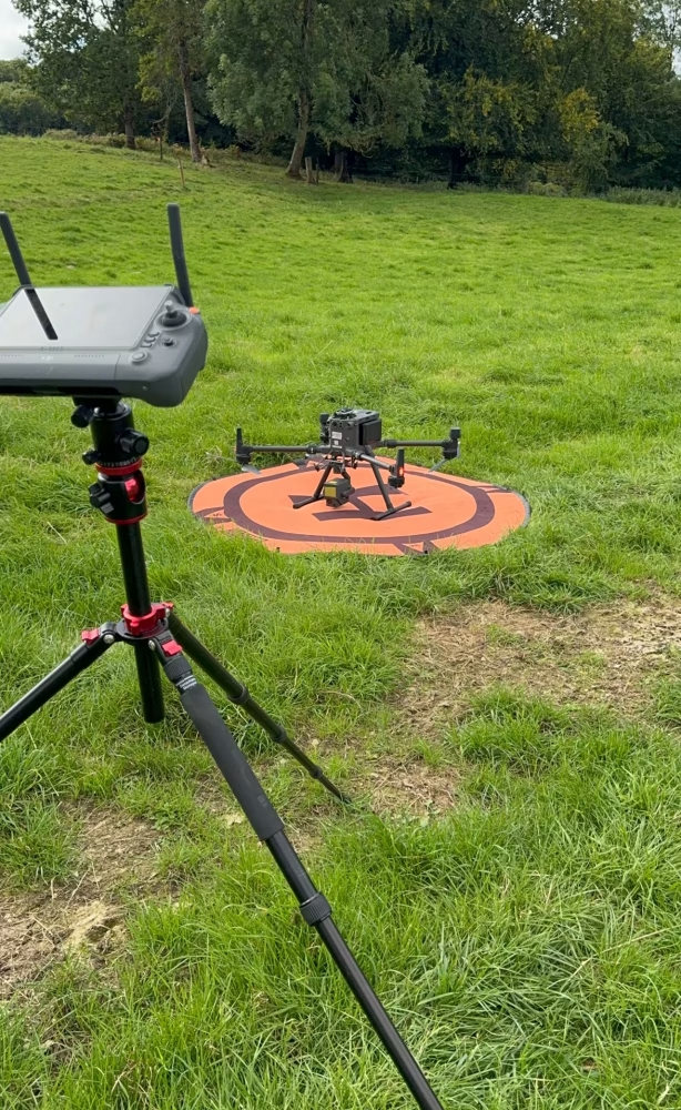
Due to recent technological advancements and reduced sensor and chip sizes, LiDAR can be mounted onto some drones. Not all drones can carry a LiDAR sensor, but the enterprise drones we use can carry several models.
Can drone lidar surveying be carried out over difficult terrain?
The accuracy of a drone LiDAR survey depends on several factors, including the area being surveyed, the quality and resolution of the sensors used, and the number of ground control points incorporated into the survey. Generally, drones can achieve accuracies down to 5 cm or less. The accuracy of a LiDAR drone survey is typically higher than that of traditional surveying techniques.
How is a LiDAR survey different from a drone survey?
Drone LiDAR surveying differs from the photogrammetry used in our aerial surveys, which cannot detect bare earth where vegetation or tree canopies are present. Photogrammetry uses images stitched together and georeferenced; LiDAR uses laser beams. Laser technology uses multiple returns to penetrate the vegetation until the hard surface is reached.
Terrestrial laser scanning has been used in construction for many years, and aerial laser scanning is somewhat newer due to the size and weight of LiDAR units. Recent technological advances have enabled smaller, lighter units to be mounted on planes and drones, enabling high-density aerial scans.
Overgrown sites or even long grass during the summer months can affect photogrammetric data collection; LiDAR should be used instead.
Mission planning differs due to the requirements for LiDAR and photogrammetry, which can be the difference between survey-grade and OK results.
Why do I need a drone LiDAR survey?
Some of the main areas where LiDAR shows its worth are in vegetation, even medium grass; LiDAR can penetrate to hit the hard surface of the ground. This is due to the number of returns from the LiDAR unit before it reflects off a surface. Many drone topographical surveys need to account for grass growth during the summer, as it can yield erroneous elevation data.
Drone LiDAR surveys are often used on overgrown greenfield sites or before planning permission is requested. Construction companies and developers can leverage this technology’s benefits in planning and construction processes.
LiDAR mapping is required for penetration of vegetation or forest canopy. Regular drone camera sensors will only capture the tops of trees or the long grass in an overgrown field. At the same time, LiDAR can penetrate the vegetation canopy until it reaches the hard ground. You can find out more about that over on our Drone Surveying and Aerial Mapping Page.
Drone LiDAR surveys generate millions of data points, each having a georeferenced value. These values are then compared with the other data points in the set, and many calculations are derived from them. Stockpile volumetrics, distance measurements, slope length and angle, building heights, and features such as windows and doors can all be extracted from the data set.
How much does a LiDAR drone survey cost?
There is no simple answer to drone lidar pricing, but generally, the size of the site or area to be surveyed determines the price. The bigger the site, the more planning and flight time are required. More data will be captured at more significant sites, resulting in more ground control points placed and recorded. Bigger sites generate more extensive data sets, which take longer to process. We generally price jobs based on sizing bands. Under 50 acres, 50 – 100 acres, etc. The required deliverables also determine the price. Contact us via email and provide as much detail as possible, and we will send you a quotation within 24 hours.
Where is a LiDAR drone survey not useful?
Drone LiDAR surveys are not suitable in all situations.
LiDAR and water do not mix well due to refraction and light absorption. That is not to say LiDAR cannot penetrate water, but it requires a specific wavelength beam, which is not typically used in land surveying.
LiDAR is generally not a good solution for coastal erosion monitoring. Photogrammetry also has challenges with water due to movement between images, but for coastal erosion, surveying can be achieved by monitoring tides.
The light spectrum is significant, and many specialised sensors can perform various tasks. These may or may not fit on current drone technology, but they will generally require custom fitting. We can provide these services and work with you to help you achieve your goals.
Can you use drones for LiDAR?
Drones are increasingly used in LiDAR surveys. With the reduction in size and price of aerial-mounted LiDAR units, the benefits of speed and coverage make drone LiDAR surveys far more economical. When properly planned and executed, the accuracy is on par with on-the-ground surveys and is often more accurate due to the millions of extra data points collected. A more granular site plan can be generated with contour details much faster than with traditional surveys, achieving the same levels of accuracy.
How accurate is the LiDAR drone survey?
We previously used the drone LiDAR survey method on a heavily vegetated site that was inaccessible due to safety concerns and dense vegetation.
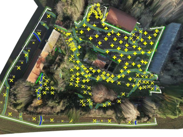
We used the L1 LiDAR on the M300 to survey the site. We incorporated on-site control points, and the drone survey’s accuracy was within 5cm across the site. The data gathered during the LiDAR drone survey enabled us to generate contours of the under-canopy surface, extract boundaries, and break lines.
Drone LiDAR mapping is excellent for the CAD and design processes where site access is restricted.

