Professional Drone Surveys in Ireland
Drone Services Ireland delivers survey-grade drone surveys and aerial mapping across Ireland. With over 10 years of specialised experience and thousands of completed projects, we’re trusted by engineers, architects, and construction teams for accurate topographic surveys, orthomosaics, LiDAR surveying, and volumetric analysis.
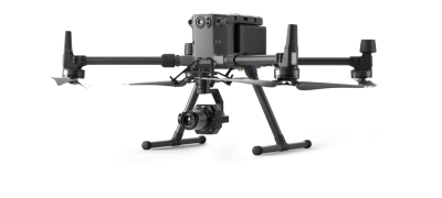
Our surveys achieve ±5cm accuracy using RTK/PPK technology and professional-grade equipment, including DJI Matrice 300 RTK platforms.
What is Drone Surveying?
Drone surveying combines high-resolution aerial imagery with precise GPS ground control points to create accurate geospatial data. Our photogrammetry and LiDAR workflows produce:
- Dense point clouds
- Digital Terrain Models (DTM) and Digital Elevation Models (DEM)
- Orthomosaic imagery
- 3D models and digital twins
- CAD-ready topographic surveys
Drone Survey Accuracy & Quality Standards
- ±5cm accuracy details
- RTK/PPK technology explanation
- Survey-grade deliverables
- Quality assurance process
Drone Survey Applications in Ireland
- Topographic Surveys – Survey-grade drawings with contours, DTMs, and CAD deliverables
- Construction Monitoring – Site progress tracking, earthwork volumes, stockpile measurements
- Infrastructure Inspections – Power lines, bridges, solar farms, wind turbines
- Volumetric Analysis – Cut/fill calculations, stockpile volumes, quarry measurements
- BIM & 3D Models – Digital twins and photorealistic models for planning
- Orthomosaic Imagery – Geo-referenced aerial maps for GIS and CAD
Drone Survey Cost & Pricing Ireland
The simple answer is that pricing varies based on several factors. There is no one-size-fits-all approach to drone survey costs, as each project is unique.
The location, size of the project, time of year, weather, airspace, and surrounding areas, such as roads and building structures, can all affect pricing.
We customise our drone land surveying prices to provide clients with the best possible data at a very reasonable price.
A drone topographic survey can achieve savings of up to 65-70%.
We consider all these factors and provide a custom price per job based on them.
Drone Services Ireland is recognised as one of Ireland’s leading drone survey companies, providing the highest quality digital aerial land surveys.


Why choose Drone Services Ireland?
Drone Services Ireland: Unmatched Expertise in Aerial Land Surveying
- ✓ Ireland’s first IAA-verified drone operator (2016)
- ✓ 10+ years specialised experience
- ✓ Secretary of Drone Professionals Ireland. Former Chair Irish Professional Drone Pilots Association, Former Co-Chair of UAAI
- ✓ Survey-grade accuracy: ±5cm (XYZ coordinates)
- ✓ Full EASA & IAA compliance
- ✓ Certified pilots across Open & Specific Categories
- ✓ Comprehensive insurance coverage
We specialise in complex, high-value drone surveys for engineers and construction/renewable energy teams.
Drone Topographic Surveys Ireland
Ireland’s rugged landscape is ideally suited to drone surveys. Take a look at the image to the right, a 3D point cloud of a mountain with an elevation difference of over 600 metres. We had significant challenges driving up the track due to the steepness, but the drone had no issues capturing the data. Leveraging terrain-following technology, the drone maintains a consistent distance from the ground, ensuring the accuracy of the captured data.
Equipment Used:
– DJI Matrice 300 RTK
– PPK/RTK accuracy: ±2-3cm
– Ground sampling distance: 1.2cm/pixel
– Flight altitude: 50-120m
– Weather conditions: Wind <12m/s

Drone Survey Equipment & Technology
We maintain one of the most up-to-date drone fleets in the country to ensure we benefit from the latest advances in drone technology while keeping client costs down by maximising the efficiency of newer platforms.
DJI M300’s with L1 and P1 payloads
DJI Matrice 4 Enterprise
DJI Mavic 3 Enterprise.
Please have a look at our Drone Equipment page for more detailed information on our fleet.

What are the benefits of drone surveying services?
In summary, the benefits of drone technology are clear.
- Speed – 4 times faster than traditional surveying
- Accuracy
- Cost Savings – 60+% savings
- Data Visualisation
Across many sectors, drone data significantly benefits many projects.
The visual aspect of drone data makes it easier to relate to.
Viewing a complete three-dimensional picture is akin to interpreting dots and lines on a page, which can only be understood by trained engineers.
The significant advantage of drone surveying over traditional surveying is the speed at which data can be delivered. Drone Surveys can cover much larger areas more quickly than conventional surveying methods.
Drone Surveying is also safer; people do not have to walk in dangerous places. Where ground control is required, it can be planned and placed safely, without the risk of twisted ankles or broken bones.

Drone Surveying Workflow - How is a drone survey conducted?
The first step in any drone survey is gathering the requirements and understanding the project with the client. We often set up online meetings to discuss and understand the project and outputs that the client requires.
The outputs from a drone survey versus an aerial mapping mission can vary and require different levels of post-processing; these requirements often dictate the drone surveying software platform chosen to process the survey data.
Comprehensive Mission Planning
Completing a successful drone land surveying mission requires as much planning before arriving at the site as it does on-site. We take the client’s requirements as a boundary KML or a Google Earth screenshot of the area.
Selecting the right drone from Our Industry-Leading fleet
We import the boundary into our flight planning software, UGCS or Pilot 2, and select the appropriate surveying and mapping drone for the mission while planning. We set up the job parameters, which vary based on requirements and include front and side overlap, ground-sampling distance calculations, flight-height limitations, etc., to accurately depict the flight and avoid costly mistakes.
Thorough Pre-Flight Checks
We conduct a risk assessment following our Specific Category Authorisation and check the weather conditions to ascertain when we can complete the mission. When on-site, we lay out ground control points in pre-determined locations and survey them. We launch the drone after all our pre-flight checks are complete, and it captures data according to our flight plan.
GDPR Compliant Processed Data
Once the data has been collected, we’ll process it. Our processing is fully GDPR compliant, so you can be assured that your data is safe and secure.
Drone Surveying and Mapping FAQs
Learn more about our Drone Surveying and Mapping Services.

How much does drone surveying cost in Ireland?
The simple answer is that pricing varies based on several factors.
The location, size of the project, time of year, weather, airspace, and surrounding areas, such as roads and building structures, can all affect pricing. We consider all these and provide a custom price per job based on these variables.
Drone Services Ireland is recognised as one of Ireland’s leading drone survey companies, providing the highest quality digital aerial surveys. We provide data-only collection services for many companies that process their own data, or we can do that for you as part of the deliverables.
We have spent thousands of hours perfecting our workflows and have heavily invested in the latest hardware and software to provide you with the best drone land surveying solutions in the country.
Adding high-precision GPS or an RTK/PPK solution increases overall accuracy. Survey ground control points (GCPs) can be input to orthorectify the image and verify its accuracy when used as checkpoints.
We use a combination of RTK and PPK workflows, depending on conditions such as mobile data coverage on the project and use the most suitable workflow. We cater to sites of all sizes, ranging from a few acres to hundreds of hectares. We price accordingly; the more significant the drone survey, the more time and processing will be involved.
This highly detailed output is accurate regarding global position and elevation, and it can be output in local coordinate systems such as the Irish Transverse Mercator (IRENET95) and Malin Head vertical datum.
What factors affect drone survey pricing?
Survey pricing varies based on site size, location, airspace complexity, required accuracy, and deliverables. We provide detailed quotes tailored to your project needs. As Ireland’s most experienced operator with survey-grade equipment and processing workflows, we deliver accuracy and reliability that exceeds industry standards.
What is the accuracy of drone surveys?
We have conducted numerous aerial photogrammetric surveys, spending hundreds of hours in the field, at the computer, and collaborating with experts to deliver survey-grade results through our workflows. We have worked with surveyors and have in-house surveyors who verify the work we complete. We achieve <5cm accuracy in X, Y, and Z coordinates.
What are the limitations of drone surveying?
In Ireland, drone surveying has two main limitations: airspace restrictions and weather. In nearly all cases, we can apply for permission to fly in restricted areas; mother nature is something we cannot control.
Wind and rain are the two main issues, but a low-cloud base can also be challenging. While our cutting-edge equipment can fly in 15 m/s winds, data quality may be affected, and we won’t take the chance. Also, while nadir data capture is standard for drone surveying, if raindrops get on the lens, the data quality is compromised again.
We plan our jobs so we can safely capture the best-quality data.
Can you provide a UAV drone survey?
Yes, we can provide a UAV Topographic Drone Surveys. Our drone services are available for projects of all sizes, including topographical mapping, 3D modelling, elevation/contour data, and orthomosaic imagery. We use the latest aerial survey equipment to ensure our data is of the highest quality and accuracy.
What projection will my data be in?
Unless otherwise advised, we produce all our survey deliverables in IRENET95 projection with Malin head vertical datum. EPSG 2157
Where do we operate?
We operate nationwide, both in the Republic of Ireland and Northern Ireland. We provide Drone and Aerial Surveying services in the country’s largest cities, including Dublin, Cork, Galway, Waterford, and Sligo. Mayo has been one of our busiest locations for large surveys in recent years.
How long does a 50-hectare drone survey take
A typical 50-hectare survey will take 1/2 a day to complete the data capture. By the time we arrive on-site, we have already completed our mission planning and GCP layout, so the time spent on-site is reduced. Based on typical survey deliverables, the results would be available by the end of the next working day, with a total time of 1-2 days.
Do I need planning permission for drone surveys?
No, you do not need planning permission for a drone survey. Drones Surveys are often used in the planning permission process, to speed up the data capture, especially on larger sites, but planning is not required for a standard drone survey.


