You can’t survey what you can’t see
Ireland’s climate means dense vegetation on any ground that hasn’t been managed for a few seasons. For engineers, planners, and environmental consultants, this is a constant headache: how do you map the ground surface when it’s buried under trees, scrub, or rushes?
Ground survey teams can work under canopy, but it’s slow, hard going, and limited by access and safety. Photogrammetric drone surveys are worse – the camera only sees the canopy top, so bare-earth mapping under vegetation is a non-starter. Drone LiDAR solves this because laser pulses pass through gaps in the canopy and hit the ground.
How it works
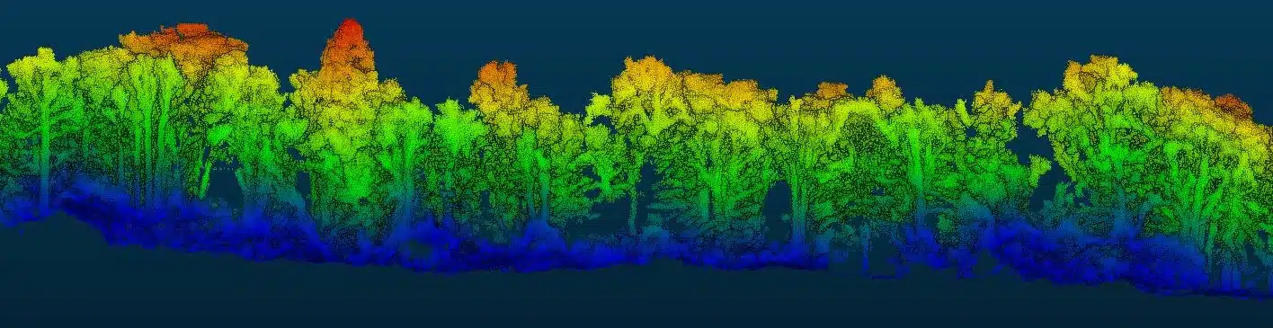
A drone LiDAR sensor fires hundreds of thousands of laser pulses per second. Each pulse is a narrow beam that travels downward. When it hits something – a leaf, a branch, the ground – part of the energy bounces back. The key thing: if the beam hits a partially transparent surface like a tree canopy, some energy reflects off the canopy while the rest continues downward and may reflect off surfaces below.
Modern sensors record multiple returns per pulse – typically 3 to 7 distinct returns. In woodland, a single pulse might give you:
- First return: top of canopy
- Middle returns: understorey, lower branches
- Last return: the ground
By classifying these returns, we separate ground from vegetation and produce a bare-earth DTM of the actual ground surface beneath the trees.
What penetration rates look like in Irish conditions
Deciduous woodland (leaf-off, November to March)
This is the sweet spot. With leaves gone, we typically get 60 to 80% of pulses through to the ground. Excellent point density for DTM generation.
Deciduous woodland (leaf-on)
Summer with full canopy drops penetration to 20 to 40% depending on species and density. Still enough for DTM generation in most cases, though ground point density is lower. Oak, ash, and beech are denser than birch or alder.
Coniferous plantation
Sitka spruce and the other conifers that dominate Irish commercial forestry are the toughest. In mature, closed-canopy stands, penetration runs at 10 to 30%. That’s workable for terrain modelling in many cases, but very dense mature plantation may need lower-altitude, higher-pulse-rate flights to get enough ground returns.
Scrub and gorse
Dense gorse – you see it everywhere on hillsides, bog margins, and abandoned farmland – is a hard surface for LiDAR. The tight interlocking branches act almost like a solid roof. We get 5 to 20% penetration, which means ground modelling through heavy gorse requires careful processing and may have some gaps.
Grassland and rushes
Long grass and rushes on wet agricultural land are effectively opaque to LiDAR. But the vegetation height is only 0.5 to 1.5 m, so the error from mapping the vegetation surface rather than ground is relatively small and can be estimated.
Where this gets used in Ireland
Forestry
Forestry surveys with LiDAR capture canopy height models (for timber volume estimation) and bare-earth DTMs (for access road design, drainage, and terrain assessment). Coillte and private forestry companies use this for planning harvesting, access routes, and replanting.
Flood risk assessment
OPW and local authority flood assessments need bare-earth DTMs for hydraulic modelling. In river corridors where riparian vegetation is heaviest, LiDAR is the only practical way to get accurate ground levels. The data feeds directly into MIKE, Tuflow, and HEC-RAS models.
Archaeological survey
LiDAR has been a game-changer for archaeology. Ground features hidden under vegetation – ringforts, field systems, earthworks, medieval settlements – show up clearly in LiDAR-derived hillshade models. Several notable archaeological discoveries in Ireland have come from LiDAR data analysis.
Power line and utility corridors
Electricity transmission line surveys need both conductor positions and vegetation clearance distances. LiDAR captures the line geometry and surrounding vegetation in one flight, enabling clearance analysis and encroachment risk identification. ESB Networks and EirGrid projects use drone LiDAR regularly for this.
Renewable energy
Wind and solar farm sites often involve terrain assessment on hillsides and farmland with varying cover. LiDAR gives you the bare-earth DTM for foundation design, access road routing, and cable trench design, even when the site is vegetated.
When to fly
For maximum penetration on deciduous sites, survey during the leaf-off period (November to March). For conifers, timing doesn’t matter much – the canopy is dense year-round.
If you need both vegetation assessment and ground survey (forestry inventory, for example), a leaf-on survey captures canopy structure and ground surface in the same flight – though with reduced ground penetration.
Talk to us
If your project involves surveying under vegetation – engineering design, flood modelling, forestry, archaeology, whatever it is – get in touch and we’ll advise on timing, expected penetration for your site, and deliverable formats. More on our LiDAR capabilities and equipment.