The world of drone surveying has soared to new heights in recent years, offering businesses and organisations across industries a powerful tool for gathering precise data and imagery from previously inaccessible or challenging terrains. But with two dominant technologies vying for your attention – LiDAR and photogrammetry – choosing the right one can feel like navigating a labyrinth.

This article will be your trusty compass, guiding you through the intricate details of drone technology: LiDAR vs. photogrammetry. We’ll delve into their unique strengths, potential limitations, and ideal applications, empowering you to choose the correct drone survey technology that aligns seamlessly with your specific project requirements.
Definition of Drone Surveying
Drone surveying, also known as unmanned aerial vehicle (UAV) surveying, uses drones equipped with specialised sensors to capture aerial data and imagery of a particular area. This data is then processed and analysed using specialised software to create detailed maps, 3D models, and other geospatial deliverables.
Drone surveying is used in a variety of sectors, including, but not limited to, agriculture, mining, construction, and real estate.
At Drone Services Ireland, we provide exceptional drone services to most of Ireland. Click here to view our range of drone survey services.
Importance of Technology Selection in Drone Surveying
Choosing the right technology between LiDAR’s precise 3D point cloud and photogrammetry’s vibrant tapestry of pixels can make or break your project. It dictates the fidelity of your data, the depth of your insights, and, ultimately, the value you extract from your aerial odyssey. Before you embark on your data-gathering flight, chart your course wisely by carefully considering your project’s unique requirements and aligning them with each drone’s strengths.
Overview of LiDAR and Photogrammetry
Soaring above the ground, drones equipped with sophisticated technology unlock new perspectives for data collection. Two prominent players in this realm are LiDAR and photogrammetry, each offering unique strengths and applications for drone surveying. Let’s dive into their core principles and uncover which drone surveying technology best fits your project.
Drone LiDAR Surveying
Definition and Explanation of LiDAR Surveying
Drone LiDAR Surveying is a powerful technology that is rapidly transforming how we map and understand the world around us. It combines the flexibility and accessibility of drones with the cutting-edge precision of LiDAR technology (Light Detection and Ranging) to create detailed 3D models of terrain, infrastructure, and vegetation.
How LiDAR Works
The drone flies over a chosen area, and the LiDAR sensor inside it acts like a laser gun, scanning the terrain below. With each ‘pass’, it meticulously measures the time each laser pulse takes to complete this round trip, and the LiDAR system calculates the distance to the reflecting object. This process happens millions of times per second, generating a dense point cloud – a vast collection of 3D points representing the precise location of everything the laser hits.

LiDAR Application in Drone Surveying
Drone LiDAR’s ability to capture accurate and detailed 3D maps and data makes it incredibly versatile for various surveying applications:
Topographical Mapping: Creating highly accurate elevation maps for construction, land development, and environmental studies.
Volume Measurements: Calculate the volume of stockpiles, excavations, or mining operations with unmatched precision.
Forestry Management: Assessing tree health, mapping forest cover, and measuring timber volume.
Infrastructure Inspection: Inspecting bridges, pipelines, and other infrastructure for damage or wear and tear.
Archaeological Surveys: Mapping and documenting archaeological sites and features in intricate detail.
Read Our Blog On: Drone LiDAR Surveying | Best Performing Drone Services Ireland
Advantages of LiDAR for Drone Surveying
Precision and Accuracy: One of the most significant advantages of Drone LiDAR Surveying is its exceptional and absolute accuracy. LiDAR data can achieve centimetre-level accuracy, far exceeding traditional surveying methods. This makes it ideal for projects that require precise measurements, such as construction planning, volume calculations, and infrastructure inspections.
Effectiveness in Vegetated Areas: Unlike photogrammetry, which struggles with dense vegetation, LiDAR can penetrate through tree canopies and foliage to map the ground level with remarkable detail. This makes it invaluable for forestry surveys, archaeological site mapping, and environmental monitoring in highly vegetated areas.
LiDAR Drone Surveying Limitations
While Drone LiDAR surveying offers numerous benefits, it’s important to consider its limitations:
Cost: LiDAR sensors and processing software are expensive, making drone LiDAR systems a costly investment compared to traditional surveying methods.
Weather Dependence: LiDAR performance can be affected by adverse weather conditions like heavy rain, fog, and strong winds, which can delay or disrupt surveys.
Data Processing: Converting LiDAR data into usable models requires specialised software and expertise, further complicating the process.
Despite these limitations, Drone LiDAR Surveying is a rapidly evolving technology with immense potential for various applications. Its unique ability to capture precise 3D data points in challenging environments makes it a valuable tool for engineers, surveyors, scientists, and other professionals who need accurate and detailed information about the world.
Ready to book your LiDAR Drone Survey?
Drone Photogrammetry in Surveying
Definition and Explanation of Photogrammetry
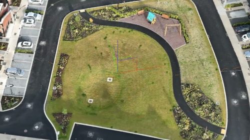
Photogrammetry in drone surveying is a sophisticated method of creating detailed 3D digital terrain models and maps using overlapping aerial photographs. It’s like putting together a giant puzzle, where each picture reveals a different angle of the same scene, ultimately forming a complete 3D image.

How Photogrammetry Works
The key principle is to capture multiple images of the same object or area from different angles. This overlap allows for identifying common points in various pictures, like finding matching pieces in a jigsaw puzzle.
Specialised software analyses the relationships between these matching points, taking into account their positions and angles within each image. This analysis uses principles of geometry and trigonometry to calculate the precise location of each point in 3D space.
By connecting these points in 3D, the software builds a virtual representation using the captured photogrammetry data. This 3D model can be incredibly detailed, capturing fine features and providing accurate measurements.
Photogrammetry turns photographs, which only capture light and shadow, into valuable data about the real world’s dimensions and shapes.
Photogrammetry Application in Drone Surveying
Photogrammetry is crucial in drone surveying, transforming aerial photographs into detailed and accurate 3D models of landscapes, structures, and objects.
Flight Planning: A pre-programmed flight path ensures complete area coverage with overlapping images. Factors like altitude, flight speed, and camera settings are optimised based on project requirements.
Image Acquisition: The drone autonomously follows the planned flight path, capturing high-resolution photographs using specialised cameras.
Data Processing: Photogrammetry software analyses captured images, identifies matching points, and reconstructs a 3D model of terrain, objects, or structures.
Advantages of Photogrammetry for Drone Surveying
Cost-Effectiveness: Compared to traditional aerial surveying methods like aeroplanes or manned helicopters, drones offer significant cost savings. Their lower operational costs and ability to access hard-to-reach areas make them an economical choice for various projects.
High-Resolution Imaging: Modern drone cameras capture incredibly detailed images with high resolution and spectral sensitivity. This enables accurate measurements, detailed 3D models, and even the identification of individual plant species in vegetation surveys.
Limitations of Photogrammetry for Drone Surveys
Sensitivity to Environmental Conditions: Weather conditions such as strong winds, heavy rain, or low light can significantly affect the quality of captured images and the accuracy of resulting models. Drone flights are often postponed or rescheduled due to unfavourable weather.
Challenges in Vegetated Areas: Dense vegetation can obscure ground features, making it difficult for software to identify matching points between images. This can lead to inaccuracies in reconstructed models, especially for areas with thick forests or tall crops.
Despite these limitations, photogrammetry in drone surveying remains a powerful tool for mapping and monitoring diverse landscapes. Its cost, efficiency, and image-quality advantages make it a valuable asset across industries such as construction, mining, agriculture, and environmental monitoring.
Comparison Between Drone LiDAR and Photogrammetry
Drone LiDAR and photogrammetry are powerful tools for creating 3D models and maps, but each has strengths and weaknesses, as outlined earlier in this article. Choosing the right technology depends on your specific drone surveying needs and the environment you’re working in.
Choosing the Right Technology
The choice between drone LiDAR and photogrammetry depends on your project’s priorities:
High accuracy and precision: Choose LiDAR for engineering surveys, construction planning, and infrastructure inspection.
Detailed visuals and textures: Photogrammetry can be ideal for capturing building facades, landscapes, and vegetation with rich visual detail.
Cost-effectiveness: Photogrammetry is generally more affordable than LiDAR, especially for smaller projects.
Environment: Opt for LiDAR in heavily vegetated areas, while photogrammetry might suffice for open landscapes or urban projects with minimal vegetation.
Drone Survey Services: Drone Services Ireland
Drone Services Ireland is a leading provider of cost-effective professional drone services across various industries, helping ensure a safer workplace and enabling inspections of buildings without risk. This ever-changing industry enhances the functionality of drones in modern business.
Drone Services Ireland covers most of the Republic of Ireland, and we complete all the appropriate paperwork and applications for each job. We are one of only a few holders of an EASA Specific Category Authorisation in Ireland, which allows us to operate our larger drones in built-up areas.
Whatever Professional Drone Solutions You Require, We Can Assist You. Call Drone Services Ireland Today!


