The Property Manager’s Guide to Drone Roof Inspections in Ireland
A practical resource for facility and property managers. Faster inspections, eliminated working-at-height risk, audit-ready insurance documentation, and compliant access for Protected Structures. To commission the inspection itself, see our drone roof inspection service (from €400, report within 48 hours).
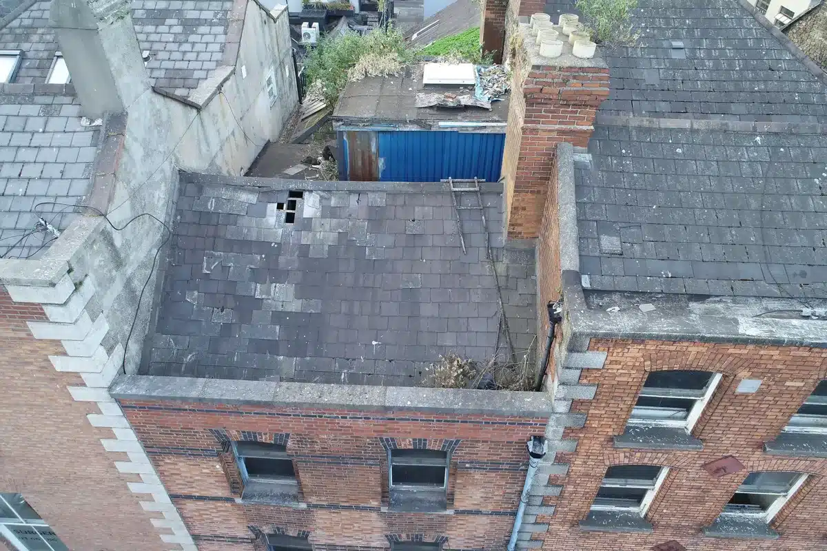
Roofs deteriorate quietly. Finding out late is the expensive part.
For most property and facility managers, the building envelope is the single largest deferred-risk line item on the maintenance ledger. Roof defects rarely announce themselves until they trigger a water-ingress claim, a tenant complaint, or correspondence from a planning authority about a Protected Structure.
Traditional roof access is slow, expensive, dangerous and – in many heritage and tenanted contexts – effectively impractical. Scaffold erection takes days; mobile elevating work platforms (MEWPs) block ground level and depend on weather; rope access requires specialist contractors and exposes operatives to falls.
A drone roof inspection eliminates all four constraints at once. The pilot stays on the ground. The capture takes hours, not days. The output is a high-resolution photographic record – timestamped, georeferenced, audit-ready, and optionally extended with radiometric thermal imagery for envelope and water-ingress investigation.
This guide explains how drone inspections work in the Irish regulatory context, where they fit alongside insurance and conservation requirements, and what to expect when you commission one.
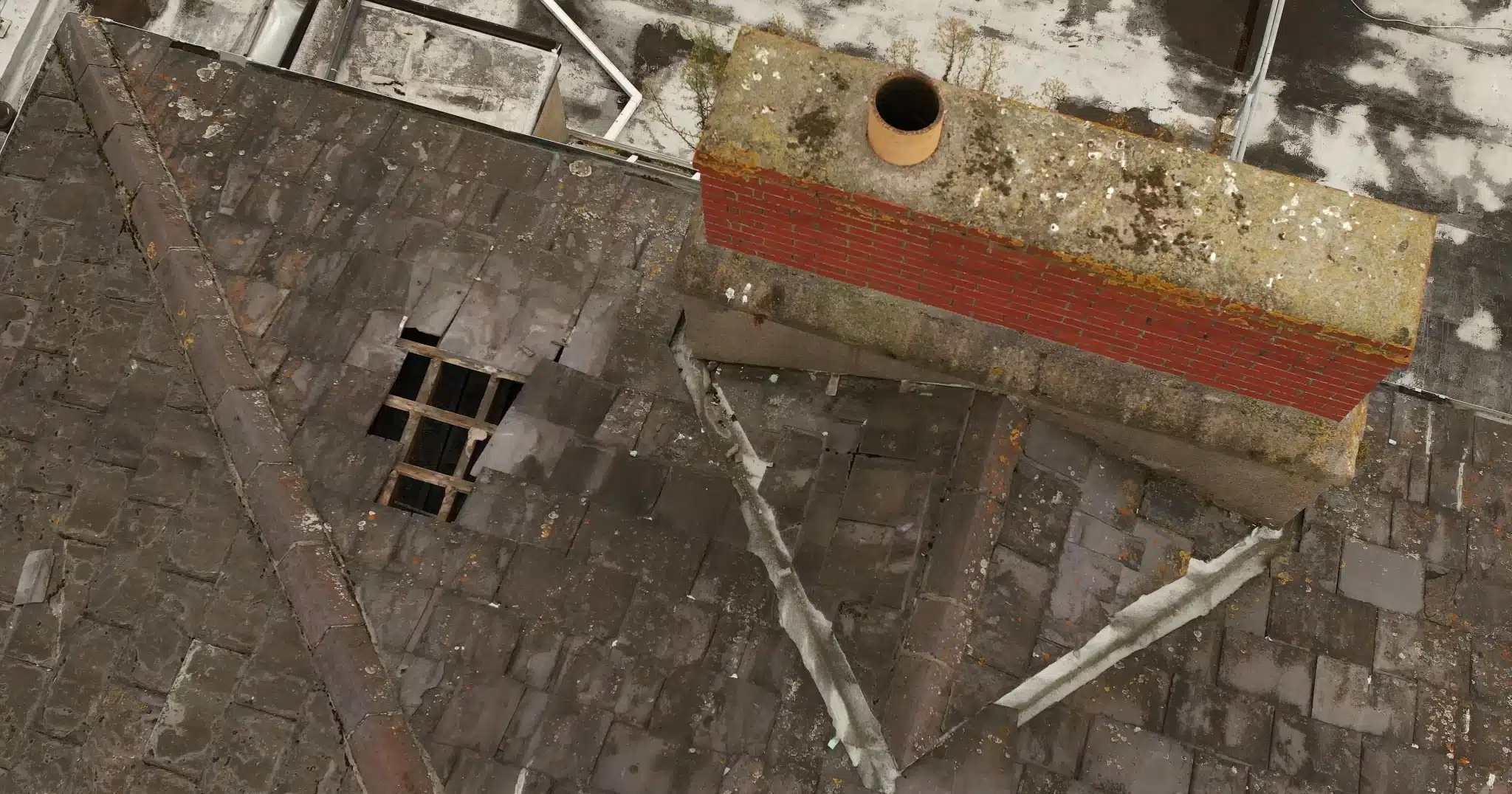
A slipped-tile defect with a clear hole, captured on a recent drone inspection of a Dublin commercial property. Spotted from ground level: invisible.
Four advantages over scaffold, MEWP, and rope access.
Safety. Zero personnel at height. Eliminates the leading category of construction fatality in Ireland and removes the chain of risk-assessment, anchor inspection, and fall-arrest compliance entirely.
Speed. Most commercial roofs surveyed in two to four hours. No scaffold erection, no street closure, no tenant lift shutdowns, no permit for ground-level obstruction.
Accuracy. 4K visual imagery as standard, with radiometric thermal available on the same flight when commissioned. Detects water ingress, insulation discontinuities, slipped fixings and electrical hotspots invisible to the human eye.
Documentation. Georeferenced, timestamped record. Audit-ready for insurers, planning authorities, tenants, and conservation officers managing Protected Structures.
A direct comparison
| Approach | Time on site | Set-up overhead | Tenant disruption |
|---|---|---|---|
| Drone | 2–4 hours | Minimal – one weather window | None |
| Scaffold | 1–2 hours of survey | 1–3 days erect + 1–3 days dismantle | Significant |
| MEWP / cherry picker | 2–4 hours | Vehicle access required, ground-level closure | Moderate |
We fly the DJI Matrice 4 Enterprise for commercial inspections – RTK positioning, mechanical-shutter 48MP wide camera, telephoto zoom, laser rangefinder. Thermal payloads (Zenmuse H20T / H30T) fly on our DJI M300 RTK.

Falls from height remain the single most preventable workplace fatality category in Irish construction.
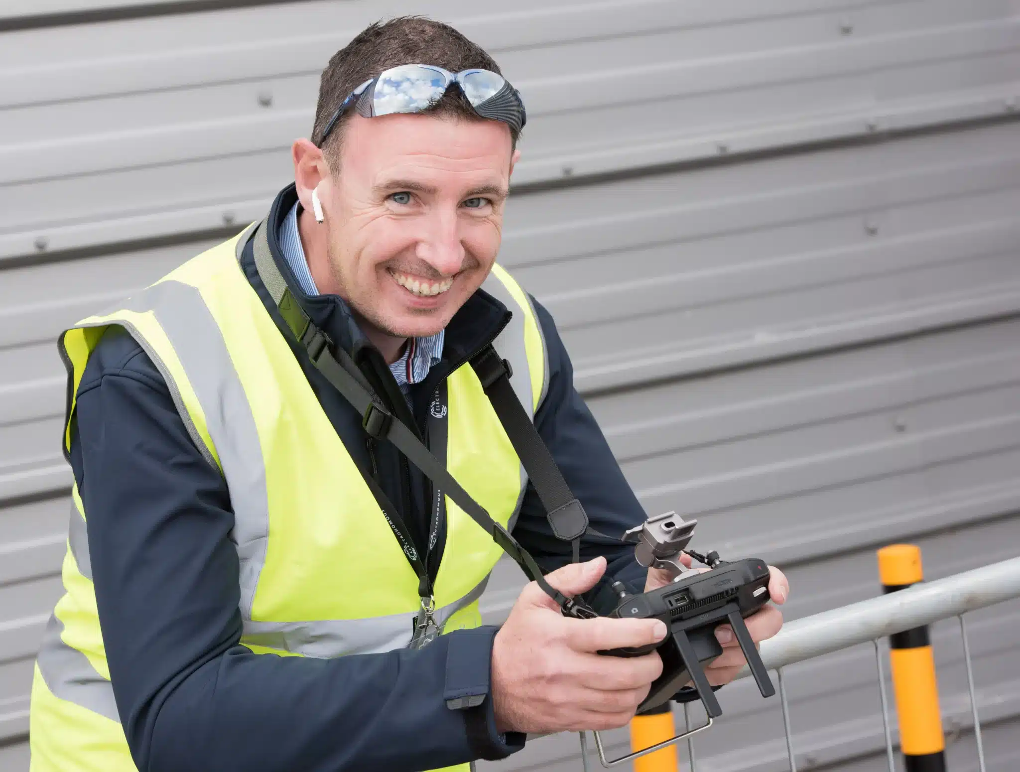
Fergal McCarthy, founder and chief pilot. Operates under EASA Specific Category authorisation and is registered with the IAA.
Under the Safety, Health and Welfare at Work (General Application) Regulations 2007, Part 4, every employer in Ireland must take all reasonable steps to avoid work at height where it is practicable to do so. When work at height is unavoidable, the regulations require collective protection, supervision, training, and equipment inspection.
A drone inspection eliminates the work-at-height risk entirely. The pilot operates from the ground, often outside the building footprint. There is no scaffold to fail, no harness anchorage to test, no operative to fall.
For property managers, this matters for three reasons. First, reduced personal-injury claim exposure on premises managed under your employer or controlling-undertaking responsibility. Second, insurance underwriters increasingly query work-at-height risk during cover review. Third, Health and Safety Authority enforcement focuses heavily on this category, and a documented preference for ground-based inspection methods strengthens any compliance narrative.
“Falls from height accounted for five workplace fatalities in 2024. In construction specifically, falls from height claimed 70 lives across the island of Ireland between 2015 and 2024.”
Source: Health and Safety Authority of Ireland, Annual Review 2024, published January 2025.
From mobilisation to delivered report, often inside 72 hours. No scaffold, no street closure, no tenant lift shutdowns.
For tenanted commercial buildings, the cost of inspection is rarely the survey itself. It is the disruption: parking blocked, fire egress restricted, ground-floor retail signage obscured, deliveries rerouted, residents notified, lifts taken out of service.
A drone inspection eliminates all of these. The on-site phase is typically a single weather window of two to four hours. There is no scaffold to erect or dismantle, no permit for street furniture, no vehicle on the pavement.
For owners of multi-unit residential or mixed-use commercial properties, this means inspections can be commissioned more frequently – quarterly or post-storm, rather than once every five years – because the friction cost has collapsed.
A typical engagement timeline
- Day 0: Enquiry received, fixed-price quote issued within 24 hours.
- Day 1–2: Flight planning, airspace clearance if needed (Dublin / Cork / Shannon CTRs).
- Day 3: Site visit, 2–4 hours, weather-dependent.
- Day 4–5: Report delivered – annotated imagery, defect register, condition rating, recommendations.

A commercial roof inspection in Cork. No scaffold. No tenant downtime.
Cork commercial estate, 4,800 m²
Single-storey industrial unit, no airspace restrictions. Surveyed in one weather window of 2 hours 40 minutes in Q3 2025. Defect register identified six items: three slipped fixings on parapet flashing, one blocked outlet on a flat-roof drainage pan, and two minor mortar gaps at the perimeter upstand. Annotated report delivered within 48 hours of capture.
For Ireland’s Protected Structures, a drone is often the only non-invasive survey method available.

Aerial photographic record of a Protected Structure in Dublin 4. A photogrammetric capture builds a permanent dimensional record that supports conservation reporting.
Under the Planning and Development Act 2000 (as amended), each local authority maintains a Record of Protected Structures (RPS). The Act replaced the older “Listed Buildings” terminology; the legal category is now Protected Structure, and protection extends not only to the exterior but also to the interior and the land within the curtilage.
Any work that would materially affect the character of a Protected Structure requires planning permission and an Architectural Heritage Impact Assessment (AHIA) signed off by a qualified conservation architect.
Scaffold contact with historic plaster, slate, leadwork or stonework can cause irreversible damage and may itself trigger Section 57 declaration scrutiny by the planning authority. Drone surveys produce a complete photographic and photogrammetric record of the roof and high-level fabric without anchoring, drilling, or contact.
For property managers overseeing protected ecclesiastical, civic, or commercial structures, a periodic drone-captured photogrammetric record also feeds directly into the National Inventory of Architectural Heritage (NIAH) condition-monitoring workflows that many local authorities now request.
If you manage a building on the RPS, ask your conservation architect whether your annual condition report can be supplemented with drone-captured imagery. In most local authority workflows, it strengthens the submission and reduces the need for invasive scaffold inspection cycles.
Regular inspection records strengthen claims, lower premiums, and satisfy underwriting reviews.
Commercial property insurance underwriters in Ireland increasingly require evidence of periodic roof inspection as part of cover renewal. The standard underwriting “envelope” assessment treats the roof as one of four primary risk components, alongside HVAC, plumbing, and electrical systems.
A documented annual drone inspection produces an evidence pack that addresses each of the questions underwriters typically ask: the age and remaining service life of the roof membrane, the condition of flashings, drainage and parapet detail, any visible water ingress, and a defect register with severity rating.
For storm-damage claims, pre-event imagery from a recent drone inspection is often decisive. It distinguishes pre-existing defect from event-caused damage – the central question in most Irish commercial property claims under named-storm cover.
Indoor inspections, confined-space surveys, deep-shadow interior valley details, and operations in sustained winds above 12 m/s remain the domain of ground-based inspection. We tell clients when a drone is the wrong tool for the job – it preserves trust on the cases where it is the right one.
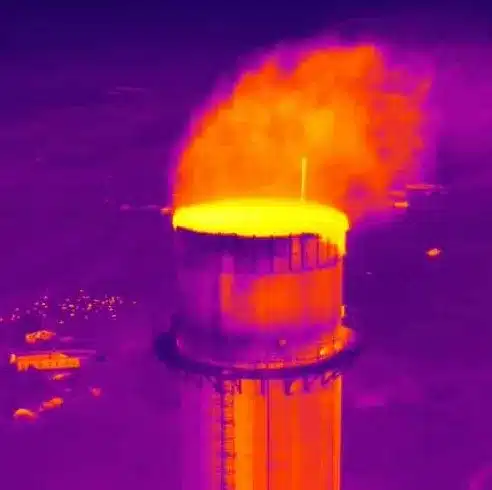
A radiometric thermal capture of an industrial chimney. Thermal imaging reveals defects invisible in visible-light photography.
- Dated, georeferenced 4K imagery
- Defect register with severity rating
- Annotated overlay of every issue
- Condition rating per roof zone
- Recommended remediation
Radiometric thermal imaging available on request as an add-on – recommended for flat-roof water-ingress investigation, solar PV defect detection, and building-envelope heat-loss surveys.
Plan your next inspection.
- Identify your two most water-vulnerable roofs – oldest membrane, lowest pitch, or known historic leaks.
- Request a fixed-price drone inspection quote for both. We respond within 24 hours.
- File the resulting reports against your next insurance renewal as evidence of due-diligence inspection.
Recommended inspection cadence
| Property type | Recommended cadence | Trigger events |
|---|---|---|
| Commercial / industrial | Annual | Post-storm, pre-tenant change, post-major-rainfall |
| Multi-unit residential | Annual or biennial | Resident complaint, post-storm, planned maintenance cycle |
| Protected Structure / heritage | Annual conservation cycle | Pre-AHIA, post-storm, repair planning |
| Roof-mounted solar PV | Annual thermal scan | Performance drop, partial-shading concern |
| High-exposure coastal | Biannual | Post-named-storm, post-winter |
droneservicesireland.ie · Navan, Co. Meath · All 32 counties covered